


Flood Protection & Information
In the aftermath of Hurricane Helene, Hurricane Milton, and Hurricane Ian the City of Cape Coral's Development Services Department is actively working to assist residents and businesses affected by the storms. Please see below for information on flood protection, awareness, and recovery.
- Helpful Links
- Floodplain Management Plan, Annual Progress Report – 2025
- Forerunner Flood Information Portal
Get Prepared
- Flood Risk Information Portal
- Flood Elevation Data
- FEMA Flood Map Revisions
- LOMA / LOMR-F Requests
- Property Planning and Protection
- Flood Insurance & Discounts
- Financial Assistance & Grants
- Dry Floodproofing Certificates (Commercial Only)
- Community Outreach Programs
Stay Safe
Recover
Flood Risk Information Portal
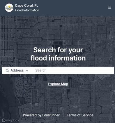
The City of Cape Coral is partnering with Forerunner to give residents easy access to flood risk information for their properties.
Some of the ways residents can utilize Forerunner include:
- Flood Risk Check: Use any address to find the property's flood zone, Base Flood Elevation (BFE), Design Flood Elevation (DFE), and other floodplain information.
- Elevation Certificates: Search for existing Elevation Certificates and important flood documents to avoid the cost of getting new ones.
- Get Help: Contact your local floodplain management team through Forerunner’s Get Help page by entering your information and property details.
Flood Elevation Data
Citizens can alternatively check flood zone information online with GIS.
Follow the search instructions shown below to:
Check your flood zone and elevation requirementsSearch Instructions:
1. After clicking on the "Check your flood zone" link and reviewing the disclaimer page, scroll down and click the blue START button;
2. A popup will appear for you to read the disclaimer and accept; once accepted, click on the “downward arrow” button on the left-hand side (top left of the screen);
3. Enter your preferred method for searching (address, owner name, etc.), then hit enter on your keyboard or click the magnifying glass, which will run the search;
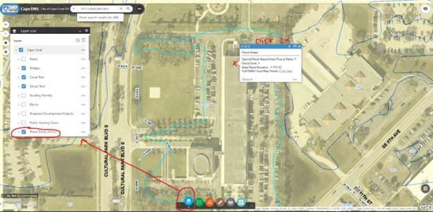
4. On the "Layer List," ensure that the box next to "Flood Zones (Firm)" is checked. Once the box for the property comes up, click on the property itself to view the parcel's flood zone information. (See image below). Scroll down to view your current flood zone and your new flood panel.
FEMA Flood Map Revisions
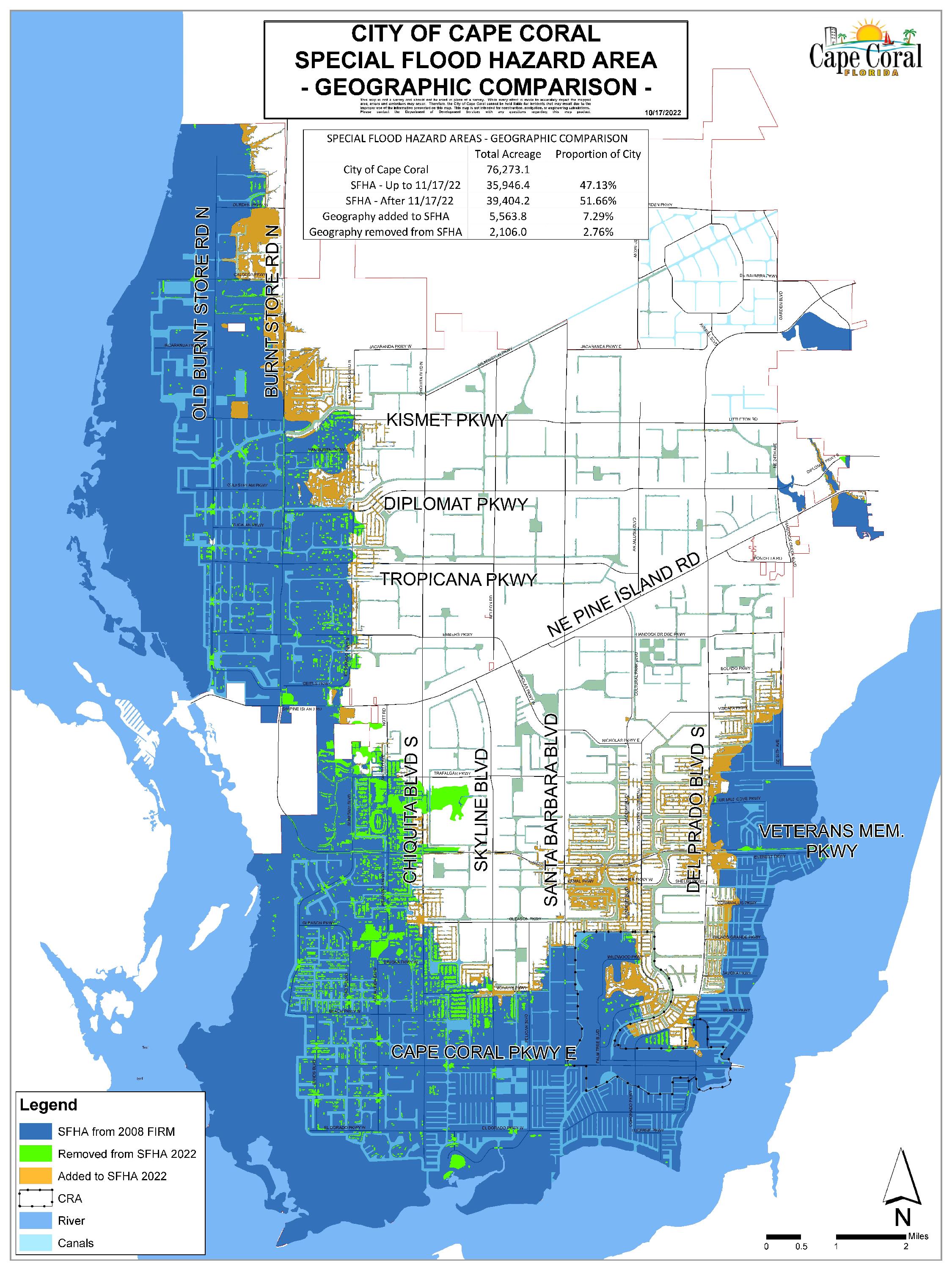
Flood Maps Changed in November 2022 - What you should know: It is important for all citizens and business owners to understand the potential risks of flooding. The federal government has issued new flood hazard maps for Lee County, which are based on updated engineering studies. Please familiarize yourself with the new maps and actions you can take to minimize health and property risks associated with flooding.
The Federal Emergency Management Agency (FEMA) has completed the first comprehensive review of flood zones throughout Lee County in 14 years. New Flood Insurance Rate Maps, which also establish required base flood elevations for construction, became effective on November 17, 2022.
View Cape Coral's new flood zone map
Find an Insurance Provider
LOMA / LOMR-F Requests
Property owners who believe their structure or parcel may qualify to be removed from the Special Flood Hazard Area can request a FEMA map change through either a Letter of Map Amendment (LOMA) or a Letter of Map Revision Based on Fill (LOMR-F). While both processes can result in a structure or parcel being removed from the mapped flood zone for insurance purposes, they apply in different situations:
LOMA – Letter of Map Amendment
A LOMA is appropriate when a property is naturally elevated above the Base Flood Elevation (BFE) without the use of fill. FEMA reviews elevation data, typically from an Elevation Certificate, to confirm that the natural ground or the structure’s lowest adjacent grade is above the regulatory flood elevation.
LOMR-F – Letter of Map Revision Based on Fill
A LOMR-F is used when fill has been placed on the property to elevate the structure or parcel above the flood elevation.
This is the most common type of map change request in the City of Cape Coral due to the widespread use of fill during site development.
Because fill modifies the floodplain, FEMA requires additional documentation, including:
A Community Acknowledgment Form (CAF) signed by the City, confirming that the structure or fill is reasonably safe from flooding and meets FEMA, State, and Local technical criteria.
How to Submit
The City provides dedicated permit types for both LOMA and LOMR-F requests through the CSS Portal. Previously issued LOMA/LOMR-F determinations are also available for viewing in Forerunner.
Property Planning
After fires, floods are the most common and widespread of all-natural disasters. Most residents of Cape Coral live in a flood zone that falls into a category called a “Special Flood Hazard Area.” These areas are the V-Zone and A-Zone on the Flood Zone map. X-Zones are not considered part of the Special Flood Hazard Area, but just because your property is in one of the less susceptible flood zones does not mean you have no need for concern. Twenty-five percent of flooding occurs outside areas formally designated as being flood-prone (i.e., Special Flood Hazard Areas).
Flood insurance is required for many property owners; however, this insurance is available to all properties in Cape Coral, including properties in the X-Zone. Due to the lower risk, these zones can be insured at a lower insurance premium than the higher-risk areas.
Property Protection Measures
Protecting your home or business from flooding begins with understanding your property’s flood risk and taking proactive steps to reduce potential damage. The following measures can help safeguard your structure before, during, and after a flood event.
Simple, No-Cost Actions
Even if you cannot make permanent improvements, there are actions you can take ahead of a storm:
- Elevate valuables and essential items to higher floors, countertops, or upper cabinets.
- Move appliances or electronics to elevated surfaces whenever possible.
- Secure outdoor items that could become debris during high winds or flooding.
Protective Improvements to Your Property
There are several long-term strategies that can reduce flood risk:
- Elevate or Retrofit the Structure
If your finished floor elevation is low relative to expected flood levels, consider mitigation options such as elevating the structure, adding compliant flood openings, or improving foundation components. Dry floodproofing is permitted only for non-residential (commercial) structures and must be designed by a licensed professional. - Use Flood-Damage-Resistant Materials
Where feasible, incorporate flood-resistant materials below the Base Flood Elevation (BFE) + 1 ft. While not a code-compliant mitigation method on its own, it can significantly reduce cleanup and repair time. - Improve Site Drainage
Re-grading your yard, maintaining swales, and clearing drainage pathways can help direct water away from the structure.
Important:
Any repairs, substantial improvements, or retrofit work to a structure located in a regulated flood zone require proper permits. Please contact the Building Division for permitting questions at (239) 574-0546.
Know Your Elevation
Understanding your elevation is key to evaluating flood risk. Elevation Certificates and other elevation data for many properties can be accessed through Forerunner, the City’s online floodplain management platform.
Buildings constructed prior to 1993 may not have an Elevation Certificate on file; homeowners may obtain one from a licensed surveyor if needed.
Need Technical Guidance?
For questions about floodplain requirements, property-specific flood risk, or mitigation options, please contact Floodplain Staff at (239) 574-0611.
Additional Resources
FEMA, the U.S. Army Corps of Engineers, and the National Flood Insurance Program (NFIP) provide extensive information on flood protection and preparedness. Helpful resources include:
- www.floodsmart.gov to learn about flood risks, insurance, and preparedness.
- FEMA and USACE publications available at local libraries and the Department of Development Services.
Flood Insurance & Discounts
Homeowner's and renter's insurance policies do not cover damage caused by flooding. It is possible that flooding waters could cause more damage to the contents than to the structure. If you are in a V-Zone or an A-Zone, you are four times more likely to experience a flood than a fire. Don’t wait for the next flood to buy insurance protection. If you don’t have flood insurance, talk to your insurance agent. There is a 30-day waiting period before National Flood Insurance Program (NFIP) coverage takes effect. Contact your insurance agent for more information on rates and coverage.
Structures under construction are also insurable. Almost any building with at least two walls and a roof is insurable against flooding through the NFIP which offers affordable, federally-backed insurance. Contents of insurable buildings can be covered by a separate policy, also making flood insurance available to renters. Unless you requested that your flood insurance policy cover the contents, it may only cover the structure.
Because the City provides more than the minimum required flood plain management, most of the properties within the City receive a Community Rating System flood insurance discount.
Click here for more information on flood insurance costs and coverage
CRS & Cape Coral’s Flood Insurance Discount
To reduce flood insurance premiums for Cape Coral properties, the City of Cape Coral is a part of the NFIP and participates in the Community Rating System (CRS), which provides flood insurance discounts to communities that adopt higher regulatory standards for floodplain management. The benefit to residents is not only lower insurance premiums, but also more flood-resilient communities. Because of the points earned in this program, owners of property in A, AE and V flood zones in Cape Coral qualify for a 25% flood insurance discount. The discount in the X Zone, where flood insurance may be optional, is 10%. The value of these discounts is $15 million annually.
Click here to check your flood zone
The City of Cape Coral joined the CRS program in 1991 and reached the city’s current CRS Class 5 rating in 2010. Based on information from CRS, the value of this discount in Cape Coral is $7.5-8 million annually, up to 2022.
Residents of Cape Coral will automatically receive this discount and may confirm it by checking for this Community Identification – Cape Coral ID# 125095 – on their National Flood Insurance Program policy.
The FEMA Flood Insurance Advocate is available to help policyholders understand complex flood insurance questions, resolve concerns, and navigate issues related to claims, underwriting, ratings, and mapping.
Financial Assistance & Grants
Every year, thousands of properties across the country experience flooding, many of which were built before floodplain management practices were established. To help reduce the impact, FEMA offers several programs that provide financial assistance to communities and property owners for flood mitigation efforts.
- Flood Mitigation Assistance (FMA) Program
- Administered through a partnership with the Florida Division of Emergency Management (FDEM), funds are to be used for projects that reduce or eliminate the risk of repetitive flood damage to buildings insured by the National Flood Insurance Program (NFIP).
- Hazard Mitigation Grant Program (HMGP)
- Administered through a partnership with the Florida Division of Emergency Management (FDEM), funds are to be used to develop hazard mitigation plans and rebuild in a way that reduces, or mitigates, future disaster losses within the community. This grant funding is available after a presidentially-declared disaster.
- Increased Cost of Compliance (ICC) Coverage
- This coverage is available if your home or business is damaged by a flood, you may be required to meet certain building requirements in your community to reduce future flood damage before you repair or rebuild. Flood insurance policyholders in high-risk flood areas may receive up to $30,000 of coverage to help offset the costs to bring their home or business into compliance with their local community's floodplain management ordinance or regulations.
- 203(k) Rehabilitation Mortgage Insurance Program
- Offered through the U.S Department of Housing and Urban Development, this loan program assists with financing of a mortgage covering the purchase or refinancing and rehabilitation of a primary single-family residence that is at least 1 year old.
Dry Floodproofing Certificates (Commercial Only)
A Dry Floodproofing permit applies to non-residential buildings that are made watertight by sealing openings with certified panels and waterproof materials. Before a dry-floodproofed building is designed, several planning considerations, such as initial and annual costs, flood warning time, building use, access and egress, floodwater velocities and depths, debris impact potential, flood frequency, and all applicable State and local requirements, must be evaluated to determine whether dry floodproofing is a feasible floodplain management measure.
This method is allowed only for commercial and other non-residential structures located below the Base Flood Elevation (BFE) in AE zones and is not permitted in VE zones. All dry floodproofing must comply with FEMA, State of Florida, NFIP, ASCE 24, and City LDC requirements, and it is not permitted for residential properties, including individual condo units.
Key Considerations
- Flood warning time and building occupancy
- Access and egress during flooding
- Floodwater velocities, depths, and debris impact potential
- Initial and ongoing maintenance costs
- Overall feasibility for the building and site
Dry Floodproofing Commercial Permit Guidelines can be found in the Permitting Document Center.
How to Apply
Dry Floodproofing permits are available through the City of Cape Coral CSS Portal.
<Back to Top>
Community Outreach Programs
The City of Cape Coral actively engages the community to strengthen flood awareness, preparedness, and resilience. Recent outreach efforts include:
- Hosting a floodplain information booth at the annual Hurricane Expo, providing residents with local flood risk resources.
- Conducting multiple presentations for realtor groups, helping realtors, buyers, and sellers understand flood zones, insurance requirements, and best practices for purchasing or selling property in a Special Flood Hazard Area.
- Presenting with the City's Emergency Management and Resilience Department at the FFMA Conference in Cape Coral and at other statewide floodplain management events, educating communities on NFIP and CRS requirements, post-storm responsibilities, and mitigation strategies.
- Supporting neighboring communities through deployment missions to assist with post-storm impact surveys.
These efforts reflect the City’s commitment to public education and proactive floodplain management.
Emergency Warning System
The Lee County Emergency Operations Center provides the Emergency Warning System for Cape Coral. A hurricane watch for Lee County will be announced if hurricane conditions are possible for our area within the next 36 hours. A Hurricane Watch means it is time to put the early stages of your hurricane plan into effect. Tune in to local radio or television stations listed for the latest distribution of emergency information. Severe weather and flood warning threats are also continuously broadcast by the National Weather Service on special weather radios on Channel 4, 162.475 MHz. Emergency vehicles may also broadcast emergency information over an amplified speaker.
|
FM Radio Stations
|
AM Radio Stations
|
Television Stations
| Station | Comcast Cable | Broadcast |
|---|---|---|
| WBBH (NBC) | 2 | 20 |
| WGCU (PBS) | 3 | 30 |
| WFTX (FOX) | 4 | 36 |
| WINK (CBS) | 5 | 11 |
| WXCW (WB) | 6 | 46 |
| WZVN (ABC) | 7 | 26 |
| WWDT | N/A | 43 |
| CAPETV | 98 | N/A |
If the County declares an evacuation advisory or evacuation order for your area, please heed the warning and give yourself plenty of time to leave the area. Click here to access maps of the evacuation routes and storm surge zones for Lee County.
Be prepared for interruptions of service from cable television and telephone providers. Because any storm can interrupt electric power, it is important that you have a radio or television that can operate on battery power and a supply of fresh batteries.
Additionally, cordless phones will not work when there is an interruption in power. If you have a telephone landline in your home, it's wise to maintain an "old fashion, plug into the wall" corded telephone device, which requires no electrical power.
<Back to Top>
Evacuation Zones and Shelters
Hurricane evacuation zones are used to identify areas that are at great risk during tropical storms and hurricanes from storm surge, flooding, and other storm-related hazards. Evacuation orders are issued by Lee County Government based on evacuation zone designations and anticipated storm impacts. If an evacuation order is issued for your zone, residents should follow guidance from local emergency management officials and relocate to a safer area.
When preparing an evacuation plan, consider where you will go, how you will get there, and who you may stay with if needed. Many residents choose to stay with friends or family farther inland or at a higher elevation when possible. It is also recommended to keep your vehicle fueled and have emergency supplies ready in case of traffic delays or changing conditions.
If an evacuation order is not in place, individuals and families should evaluate their personal circumstances and determine whether to evacuate or shelter in place based on their comfort level, location, and preparedness. We empower you to decide what is best for you and your family.
Find your evacuation zone
Learn more about sheltering in place and emergency shelters
Flood Information, Mitigation, and Safety
Cape Coral’s Flooding Threat
Flooding in Cape Coral stems from two sources: heavy rain and storm surge. Aside from localized street flooding, the Cape's stormwater infrastructure generally protects homes and businesses well during rainstorms, though it can be overwhelmed by prolonged heavy rain or clogged pipes.
Storm surge, usually tied to hurricanes, poses a bigger threat and can reach as high as 25 feet in an intense storm. The most vulnerable areas lie along the coastlines of Charlotte Harbor, the Caloosahatchee River, and Matlacha Pass. For example, the 1926 Hurricane brought tides up to 12 feet above normal at Fort Myers and Punta Rasa, while Hurricane Donna produced 10- to 11-foot high-water marks on Estero Island in 1960.
Every hurricane behaves differently, so if a hurricane watch is issued, base your action plan on the specifics of that storm rather than past events. For instance, Hurricane Charley (2004) made landfall near Cayo Costa with 130-knot winds, but its shrinking eye confined those extreme winds to a small area, limiting storm surge. Eighteen years later, Hurricane Ian struck nearly the same spot, but as a larger, slower storm, it generated a far greater surge.
What You Can Do
Never dump or throw anything into swales, drainage inlets, canals, basins, or rivers, including lawn clippings, horticultural trimmings, dirt, fill material, or construction debris (Code of Ordinances Section 9-15). If your property borders a drainage inlet, canal, or river, keep inlets open and banks clear of brush and debris, and keep in mind that any dirt or lawn clippings that are blown into the street will eventually be washed into the drainage system. Construction sites must also use erosion protection devices, since silt and sand runoff can reduce the drainage system's capacity and impair its ability to carry water away. Report any dumping into the stormwater system or a waterbody to Code Enforcement at (239) 574-0613.
Before building on, altering, regrading, or filling your property, check with the Department of Development Services, Building Division at (239) 574-0546, as a permit may be required to prevent drainage problems on your property or neighboring ones. Report unpermitted building or filling to Code Enforcement at (239) 574-0613.
Safety During and After Flooding
Don't walk through flowing water. Drowning is the leading cause of flood deaths, mostly during flash floods. Just six inches of moving water can knock you off your feet, and currents can be deceptive. If you must cross standing water, use a pole or stick to check the ground ahead. Floodwater can also carry disease-causing microorganisms.
Don't drive through flooded areas. More people drown in vehicles than anywhere else. Never drive around road barriers; the road or bridge beneath may be washed out.
Avoid power lines and electrical wires. Electrocution is the second-leading cause of flood deaths, since electrical current travels through water. Report downed lines to the power company or the City's Emergency Operations Center at (239) 573-3022, and disconnect electricity and gas before flooding hits.
Watch for animals, especially snakes. Displaced small animals may seek shelter in your home. Use a pole or stick to check and turn over debris and scare them away.
Look before you step. Post-flood debris often includes broken glass and nails, and mud-covered floors and stairs can be very slippery.
Never run a generator indoors or in an attached garage. Portable generators emit deadly carbon monoxide, so operate them only outdoors in a well-ventilated, dry spot, away from home air intakes and direct rain exposure. A carbon monoxide detector is a worthwhile investment if you own one.
Substantial Damage/Substantial Improvement
Repairs and Permitting
All improvements and repairs of structures in the Special Flood Hazard Area require a permit, including the submission of a Substantial Improvement/Substantial Damage application from the City of Cape Coral.
If you had work done without a permit you will need to apply for the applicable permit to put your structure back into compliance. A remodel permit is required for repairs that include any of the following: drywall, baseboards, flooring, cabinets, electrical, plumbing, etc. Please click the Document Center link where you will find what documents are required for the permit.
To apply for the required permits online please click the CSS link.
If you have additional questions for after the fact permits or need further assistance please email FEMAPackets@capecoral.gov.
National Flood Insurance Program (NFIP) & Definitions
If your home or business is in the Special Flood Hazard Area (SFHA) and is not flood compliant (i.e. structure is below Freeboard, which is FEMA BFE + 1 foot), the City of Cape Coral has flood damage prevention regulations that may affect how you remodel, renovate, or add on to your building.
The NFIP requires that any structure located in the SFHA where the cost of proposed improvements or repairs equals or exceeds 50% of the value of the structure must be brought into full compliance with current flood damage prevention regulations.
These laws are required by the NFIP to protect lives and investment from future flood damages. Our community must enforce these laws in order for federally-backed flood insurance to be made available to Cape Coral residents and property owners. Cape Coral, following the NFIP requirements, has the responsibility to determine "substantial damage" and "substantial improvement," and has implemented the procedures to do so.
|
SUBSTANTIAL DAMAGE |
SUBSTANTIAL IMPROVEMENT |
|
Definition: means damage of any origin sustained by a structure whereby the cost of restoring the structure to its ‘before damage’ condition would equal or exceed 50% of the market value of the structure. (Note: The cost of the repairs must include all costs necessary to fully repair the structure to its “before damage” condition.)
|
Definition: means any reconstruction, rehabilitation, addition, or other improvement of a structure, the cost of which equals or exceeds 50% of the market value of the structure (before any improvements are performed). |
|
NFIP requires that if a building had substantial improvement or substantial damage, then the building must meet current flood zone construction requirements. Article 9 of the City of Cape Coral Land Development Code specifies details on flood damage prevention. |
|
Helpful Links
- Lee County All Hazards Guide
- Lee County Evacuation Routes and Storm Surge Zones
- Forerunner Flood Risk Information Portal
- Floodplain Management Plan, Annual Progress Report – 2025
- Hurricane Damage? View federal and state mitigation program information
- Risk Rating 2.0 Equity in Action
- Florida Risk Rating 2.0
- FloodSmart.gov: To learn about flood risks, insurance, and preparedness.
- Find Elevation Certificate
- Flood Insurance Costs and Coverage
- AlertLee Emergency Notification System